When India Meteorological Department (IMD) released its October 1, 2025 bulletin at 13:30 IST, the nation braced for a cascade of rainstorms that would touch everything from the arid coast of Gujarat to the mist‑shrouded hills of the Northeast.
The agency warned of a depression brewing over the west‑central Bay of Bengal, set to unleash isolated heavy to very heavy rainfall across eastern India from October 2‑5, with an especially fierce deluge predicted over Odisha on the 2nd.
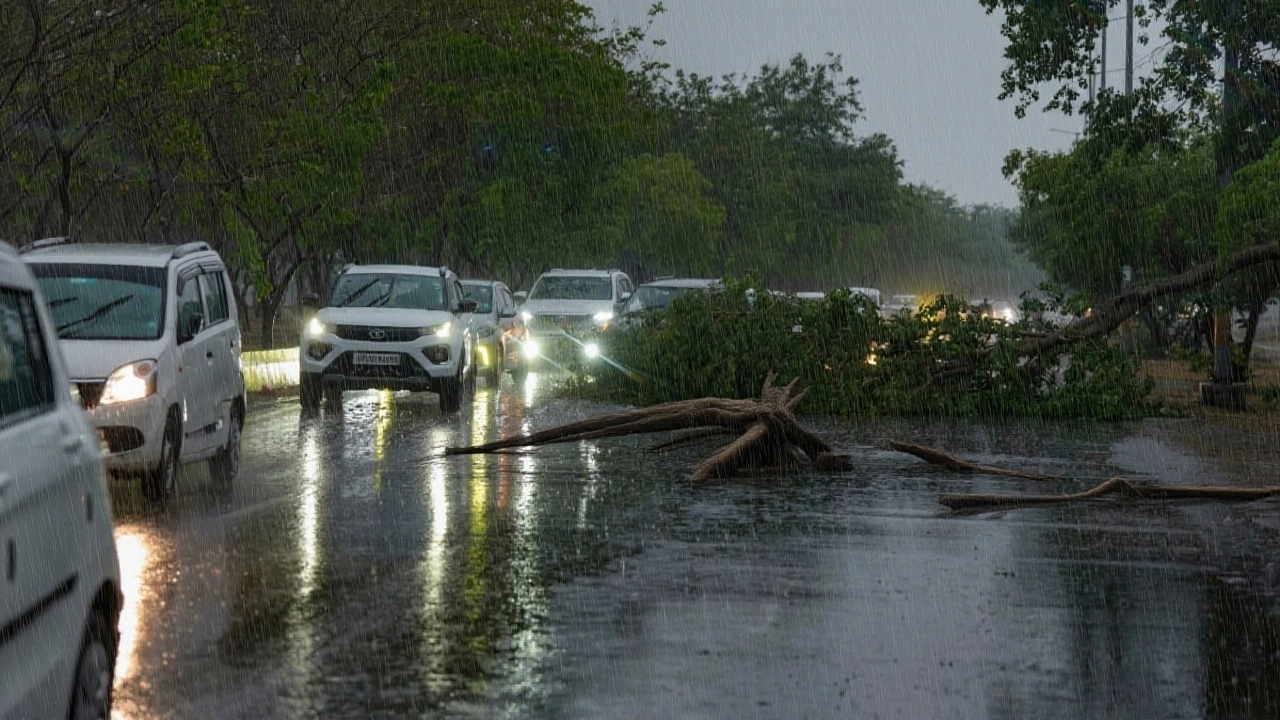
But the most urgent alerts landed in Gujarat, where three districts were slapped with a red‑level warning. Gir Somnath, Junagadh and Porbandar now sit in the danger zone, while neighbours Amreli, Rajkot and Devbhoomi Dwarka sit at orange, and the rest of the state is on a yellow alert. Heavy rain is expected state‑wide until October 2.
Current Alerts Across Gujarat and East India
The red alerts in the Saurashtra peninsula stem from a low‑pressure system lingering over the Gulf of Kutch. Meteorologists say the system will dump "isolated heavy rainfall" on coastal tracts from September 30 through October 2, with gusts that could topple weak structures and flood low‑lying fields.
"We are seeing a classic convergence of moisture from the Arabian Sea and the Bay of Bengal," explained Dr. K. R. Sreenivasan, Director General of India Meteorological Department. "The red‑alert districts should activate emergency response plans immediately – that means pre‑positioning sandbags, clearing drainage, and alerting schools to stay closed if water levels rise beyond safe limits."
In the east, the depression over the Bay of Bengal is expected to intensify on October 3, delivering 7‑11 cm of rain in isolated pockets of West Bengal, Odisha and adjoining parts of Jharkhand. The IMD’s model shows a 40 % probability of "extremely heavy" rainfall (exceeding 12 cm) in coastal Odisha on the 2nd, a scenario that could trigger flash floods in the coastal delta.
Rainfall Outlook for Maharashtra and Western India
Turning west, the agency pegs Maharashtra for a milder, though still persistent, wet spell. Light rains and occasional thundershowers will sweep the Marathwada belt from Tuesday onward, while the Konkan‑Goa stretch, southern Madhya Maharashtra and isolated pockets of North Madhya Maharashtra will see intermittent showers through October 5.
Mumbai and Pune—India’s bustling financial hubs—are slated for light to moderate rain until October 3, with Pune possibly lingering under drizzle until the 5th. "Urban drainage systems are already strained from the monsoon’s tail end," noted Rohit Deshmukh, a senior analyst at the Indian Institute of Tropical Meteorology. "If any of the red‑alert zones in Gujarat see runoff spilling into the western coastal currents, we could see a secondary rise in sea‑level pressure that might affect the Konkan coast, albeit modestly."
What the Recent Heavy Showers Mean
In the past 24 hours (up to 08:30 IST on October 1), the IMD recorded 7‑11 cm of rain at isolated spots across a swath of states: Assam, Nagaland, Sub‑Himalayan West Bengal, West Uttar Pradesh, East Rajasthan, Arunachal Pradesh, Jharkhand, Delhi, and coastal Karnataka. The sheer geographic spread hints at an active monsoon withdrawal phase, where the retreat line sliced through 20°N/69°E, Veraval, Bharuch and Ujjain.
Night‑time temperatures are hanging 3‑5 °C above normal in much of north‑west India, a side effect of the lingering cloud cover. The IMD warns that as forecast lead periods lengthen, accuracy tapers, making the red‑ and orange‑level warnings the most reliable triggers for on‑ground action.
Expert and Local Responses
Gujarat’s Chief Minister, Bhupendra Patel, issued a terse statement on October 1: "We have activated the State Disaster Response Force in the red‑alert districts and are coordinating with local municipal bodies to ensure swift evacuation where required."
Meanwhile, the National Disaster Management Authority (NDMA) reminded citizens that "rain‑related accidents, landslides and water‑borne diseases" remain a top concern. Health officials in Mumbai urged residents to keep oral rehydration salts handy and to avoid standing water where possible.
Potential Impacts and Future Outlook
Beyond the immediate flooding risk, the wet spell could affect agricultural yields in Gujarat’s Kutch and Saurashtra regions, where cotton and groundnut crops are nearing harvest. A 2024 study by the Indian Council of Agricultural Research warned that a 10 % drop in rainfall during the critical pre‑harvest window could shave up to 15 % off yields.
Looking ahead, the IMD flagged a fresh, intense western disturbance slated for north‑west India between October 5‑7, with its peak on the 6th. Such disturbances typically bring bouts of rain and strong winds, potentially compounding the already saturated soils of Rajasthan and Punjab.
- Red alerts: Gir Somnath, Junagadh, Porbandar (Gujarat)
- Orange alerts: Amreli, Rajkot, Devbhoomi Dwarka (Gujarat)
- Heavy rain expected: October 2‑5 in East India, especially Odisha
- Light to moderate rain: Mumbai & Pune until October 3‑5
- Next major system: Western disturbance Oct 5‑7, peak Oct 6
Frequently Asked Questions
How will the red alerts affect daily life in Gir Somnath, Junagadh, and Porbandar?
Residents can expect school closures, suspension of public transport, and possible evacuations in low‑lying neighborhoods. Local authorities have pre‑positioned sandbags and are monitoring river levels 24/7 to issue timely flood warnings.
What caused the sudden surge of heavy rain in the Northeast?
A deep‑layered monsoonal trough combined with the Bay of Bengal depression created a moisture corridor that funneled humid air into the hills of Assam, Nagaland and West Bengal, resulting in 7‑11 cm of rainfall at isolated spots within the past 24 hours.
Will Mumbai’s infrastructure handle the expected light showers?
City engineers say most drainage systems are coping, but clogged sewers in older suburbs could still cause localized flooding. Residents are advised to keep emergency kits ready and avoid driving through water‑logged roads.
How does the upcoming western disturbance differ from the Bay of Bengal depression?
The western disturbance originates over the Mediterranean‑Central Asia region and brings cooler, drier air that clashes with the moist monsoon envelope, often producing scattered rain and strong gusts in north‑west India. The Bay of Bengal depression, by contrast, draws warm, moisture‑laden air from the ocean, leading to longer, heavier rainfall events.
What precautions should farmers in Gujarat take amid the heavy rain warnings?
Agricultural officers recommend securing harvested crops, reinforcing irrigation canals, and delaying sowing of short‑duration varieties until the soil moisture stabilises. Early harvesting of vulnerable cotton bolls is also advised to prevent loss.